


Last updated on April 7th, 2024
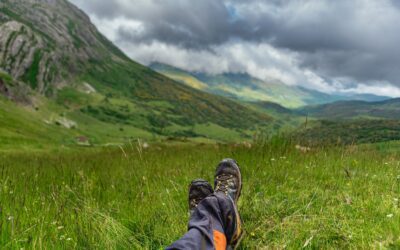
Featured Image: Hiker Sonya Richmond hikes a section of Eastern Manitoba / Photo provided by Sonya Richmond
Expert tips to hike Canada coast to coast
by Amanda Burgess
There’s little more mind clearing and spirit cleansing thana a long walk in the great outdoors, so we reached out to experts to get their recommendations for the best hiking trails in Canada. Women have been hitting Canada’s trails in record numbers since the start of the pandemic. Our recent What’s Your Travel Lifestyle? pulse survey showed that 68% of our audience of mature women travellers favours adventure travel activities like hiking and walking.
According to a Léger survey released in November by Trans Canada Trail – a team dedicated to the development and use of The Great Trail, the world’s longest network of recreational multi-use trails – usage among Canadians is up by close to 50%. What’s more, the same survey reports that 64% of Canadians ages 65 and older intend to use the country’s trails throughout the winter season.
The spike in interest and usage has sparked expanded investments in trail development along The Great Trail, which spans more than 27,000 kilometres from St. John’s Newfoundland to Victoria, British Columbia. Trans Canada Trail’s Trisha Kaplan, Trail Development Manager for Western and Northern Canada says that the Great Trail has partnered with AccessNow to increase accessibility on trails across the country, and Outland Youth Employment Program to train Indigenous youth across Canada on all aspects of sustainable trail development, including trail design, planning, construction, and signage.
No matter your hiking skill level – novice, intermediate, or advanced – everyone has a preference and style. Some women are day hikers. Others live for multi-day trips deep into the backcountry. Some take trips centred around hiking, while others work hikes into their travel itineraries as one of many activities.
The diversity of Canada’s vast and wild topography offers hikers of all levels a dizzying array of experiences and landscapes to explore – from wilderness trails like New Brunswick’s Fundy Footpath, to picturesque cycling trails like Prince Edward Island’s Confederation Trail, to beautiful urban trails like Vancouver’s Stanley Park.
Whether you’re a Canadian looking to explore more of your own backyard in 2021 or an international traveller plotting your next adventure in Canada, we offer you a compliation of the best hiking trails for women of all experience levels and interests as selected by a panel of experts.

Our expert hikers
Trisha Kaplan
Trail Development Manager for Western and Northern Canada, Trans Canada Trail
As Trail Development Manager for Western and Northern Canada, Trisha Kaplan works with partners and stakeholders on trail improvement projects, accessibility initiatives, and Indigenous programs for The Great Trail, which links over 15,000 rural, urban, and Indigenous communities from coast to coast. She believes deeply that outdoor activity helps us stay healthy physically, emotionally, mentally, and socially, and strives to ensure that everyone has access to this opportunity. Her education is in the areas of both recreation and accessibility and she volunteers in her community for safer active transportation options.

Jennifer Dubois
Visitor Experience Infrastructure Advisor, Camping and Accommodation for Parks Canada
Parks Canada is an agency of the Canadian government run by a chief executive reporting to the Minister of the Environment and Climate Change. The agency acts as guardian to 48 National Parks, three National Marine Conservation Areas, 171 National Historic sites, one National Urban Park, and one National Landmark (Pingo Canadian landmark in the Northwest Territories).

Sonya Richmond
Member of the Canadian Explorers Club and Fellow, Royal Canadian Geographic Society
In 2019, Sonya Richmond sold her house, donated her possessions, and quit her job to begin a four-year adventure hiking across Canada to promote diversity in outdoor activities and to inspire youth to reconnect with nature through birding and Citizen Science.
Canada’s Top 10 Hiking Trails for Women
Forest, mountain, meadow, glen, prairie path, urban trail, ravine, canyon, or mossy footpath – there’s a trail to suit a hiker’s every mood across the vast typography of Canada. Industry experts and hikers with decades of experience share their best hiking trails in Canada.
1. Casque Isles Trail | The Great Trail (recommended by Sonya Richmond)
Location: Ontario (links the communities of Terrace Bay, Schreiber, and Rossport)
Nearest Major City: The trail is located a 2.5-hour drive from Thunder Bay, Ontario and a 12-hour drive from Toronto, Ontario
Season: Year-round
Trail Rating: Difficult
Google Maps Link

Best for the active hiker looking for an adventure, this forested trail stretches 53 kilometres (33 miles) along the north shore of Lake Superior, offering panoramic views over the lake, treks along boulder beaches, and quiet sandy inlets, with established campsites throughout. Whether you’re a novice or pro, the trail is divided into five segments with 11 access points, so you can conquer it in small day hike sections (5 to 10 kilometres a day) or plan a multi-day hike (15 to 25 kilometres a day) and complete it over a long weekend.

Casque Isle Trail, Ontario Photo provided by Sonya Richmond
2. East Coast Trail | The Great Trail (recommended by Sonya Richmond)
Location: Newfoundland (connects historic communities from Topsail Beach, to Cape St. Francis, to Cappahayden)
Nearest Major City: The trail is located a 52-minute drive from the city of St. John’s, Newfoundland
Season: Spring, summer, and fall (winter hiking strongly discouraged along sections of the trail
Trail Rating: Offers easy, moderate, and difficult trail segments
Google Maps Link

The East Coast Trail is a 336-kilometre (209-mile) series of footpaths along the rugged coast of the Avalon Peninsula. It offers views of whales, icebergs, a nature wave-driven geyser called The Spout, and the largest Atlantic Puffin colony in North America. Perfect for avid photographers, adventurers and hikers of all abilities, you can experience abandoned settlements, lighthouses, ecological reserves, a 50-metre suspension bridge, two active archaeological dig sites, and more. There are several hikes to complete along the 336 kilometres of coastal trails. Experienced hikers might enjoy the 17.2-kilometre Long Shore Path between Topsail Beach and Portugal Cove (6 to 8 hours, rated moderate to difficult) or the 18.2-kilometre White Horse Path (8 to 10 hours one way, rated strenuous), which offers a wilderness campsite (Patch Brook Campsite) with no reservations required. Accessed at Biscan Cove with road shoulder parking, the 7-kilometre (2 to 4 hours, rated easy) Biscan Cove Path offers hikers of all levels some beautiful coastal scenery.

Hiker Sonya Richmond on the East Coast Trail in Newfoundland, Canada
3. Fundy Footpath | The Great Trail (recommended by Trisha Kaplan & Sonya Richmond)
Location: New Brunswick (starts at the Fundy Trail Parkway from Big Salmon River to Fundy National Park, which connects to the Dobson trail)
Nearest Major City: Fundy Trail Parkway is a 1 hour and 45-minute drive from Moncton airport
Season: Spring, summer, and fall
Trail Rating: Strenuous
Google Maps Link

This is a strenuous footpath stretching 41 kilometres (25 miles) through pristine coastal wilderness with a cumulative elevation gain of 3,000 metres (10,000 feet). Photographers must be willing to carry equipment over difficult terrain, but the reward is photo-worthy scenery. Great for experienced hikers looking for a challenge with its elevation gains and strenuous terrain. There are many backcountry campsites along the trail for those looking to brave the full trail on a multi-day trip. It can be done both directions, but trail guides app AllTrails recommends starting in Alma (Fundy National Park Goose River Trail) and ending in St. Martin’s so you complete the hardest section of the hike first.

Fundy Footpath, New Brunswick Photo provided by Sonya Richmond
4. High Rockies Trail | The Great Trail (recommended by Trisha Kaplan)
Location: Banff, Alberta
Nearest Major City: This trail is located just outside of Canmore, Alberta (a 1 hour and 13-minute drive from Calgary)
Season: Year-round
Trail Rating: Difficult
Google Maps Link

This 80-kilometre trail is the westernmost section of The Great Trail in Alberta offering outstanding scenery and a short boardwalk section. It travels uninterrupted through three provincial parks (Bow Valley Wildland, Spray Valley and Peter Lougheed) to finish on the Alberta-British Columbia border at Elk Pass. Nature lovers can experience wildflowers in season, including fireweed, asters and arnica.
In the fall, sections of the trail are ablaze with yellow aspen and larch. Birders can observe close to 120 bird species. Bear, moose and coyote sightings are common, so be sure to carry bear spray/pepper spray. The trail is most easily traversed in manageable day hike sections, as camping for through-hikers is difficult, especially for backpackers. There are only four established campgrounds that don’t require reservations and wilderness camping is either not allowed or not practical anywhere along the High Rockies Trail. For those who pre-plan their itinerary, there are reservation-required campgrounds in Peter Lougheed Provincial Park.

High Rockies Trail, Alberta Photo provided by Trans Canada Trail
TIP: The Hiker with Mobility Issues
5. Slocan Valley Rail Trail | The Great Trail (recommended by Trisha Kaplan)
Location: British Columbia
Nearest Major City: The trail is a 20-minute drive from Nelson, a four-hour drive from Vancouver, British Columbia; Calgary, Alberta; and Spokane, Washington
Season: Year-round
Trail Rating: Easy
Google Maps Link

Winding gently through one of the most beautiful river valleys in British Columbia, the Slocan Valley Rail Trail offers easy access to 50 kilometres (31 miles) of breathtaking scenery that can be enjoyed by hikers of all levels. Following the contours of the Slocan River, the trail makes its way from Slocan Lake in the North, towards the Kootenay River in the South, and can be easily accessed at any one of eight trailheads complete with parking, information kiosks and rest facilities.

Slocan Valley Rail Trail, British Columbia
6. Itijjagiaq Trail | The Great Trail (recommended by Trisha Kaplan)
Location: Katannilik Territorial Park, Nunavut
Nearest Major City: The trail runs from Nunavut’s capital city of Iqaluit to Kimmirut. Iqaluit is reached from Ottawa and Montreal on First Air, Canadian North and Air Canada. First Air, Canadian North and Calm Air also have flights to Iqaluit from Rankin Inlet, which is reached by airlines from Winnipeg, Churchill and Yellowknife.
Season: Summer – mid-July to late August is the best time of year to see Katannilik’s vivid arctic bloom, including purple saxifrage, bluebells and dwarf fireweed. Late summer and early fall offer hikers views of a wide variety of berry plants.
Trail Rating: Difficult
BRMB Maps Link

This 143-kilometre (89-mile) trail is a traditional Inuit route between Frobisher Bay and Kimmirut that offers stunning views of the lush tundra wilderness of Katannilik Territorial Park. From Iqaluit, you can hire an outfitter to transport you across Frobisher Bay (1-hour boat ride) to the trail head. There are nine warming huts long the trail that traverses some formidable terrain. Build up your route-finding and backcountry skills before tackling this one. The trail is a nature-loving photographer’s arctic dream, with sightings of caribou arctic wolves, arctic foxes, red foxes, lemmings, hares, peregrines, snowy owls, rough-legged hawks and sometimes polar bears. As its name means the park is full of waterfalls, with the largest being Soper Falls and Cascade Falls the highest.

Itijjagiaq Trail, Nunavut Photo provided by Trans Canada Trail
7. Celtic Shores Coastal Trail | The Great Trail (recommended by Trisha Kaplan & Sonya Richmond)
Location: Cape Breton Island, Nova Scotia
Nearest Major City: The island is almost a 4-hour drive from Halifax, Nova Scotia
Season: Year-round
Trail Rating: Easy
Google Maps Link

Best for the casual hiker, this is an easy, flat, multi-use trail spanning 92 kilometres (57 miles) that links five communities along the coast of Cape Breton Island. Fishing harbours, beaches, restaurants, accommodations, and Celtic music can be enjoyed along the trail.

Celtic Shores Coastal Trail, Cape Breton Island, Nova Scotia Photo provided by Sonya Richmond
8. Ivvavik Fly-in Base Camp, Ivvavik National Park (recommended by Jennifer Dubois)
Location: Ivvavik National Park, Yukon
Nearest Major City: Inuvik, Northwest Territories
Season: June and July
Getting There: You can get to Inuvik by driving the Dempster Highway from Whitehorse, Yukon or take a daily flight from southern Canada on Air North, Canadian North or First Air
No Google trail maps available, these are guided hikes
This is a bucket list guided adventure for hikers to put on their radar in 2022 and beyond. It starts with a scenic flight aboard a Twin Otter bush plane flying over the Mackenzie Delta and into the heart of the British Mountains. When you arrive at camp, you settle into your comfortable furnished prospector tent surrounded by mountain wilderness. Hiking options in the park are limited by COVID-19, due to significantly impacted visitor safety services. You can still work up an appetite hiking with a Parks Canada staff member, then enjoy meals on the cookhouse’s screened-in deck and spend time with your Inuvialuit host hearing stories and learning about the local culture on their traditional land.
The Ivvavik Fly-in Base Camp in Ivvavik National Park is operating in the 2021 season, but due to current Government of Northwest Territories travel restrictions, all non-residents should defer their trip and trip planning until 2022. Check Parks Canada’s website regularly for the current status of other Parks Canada locations.

Ivvavik Fly-in Base Camp, Yukon
9. Skyline Trail, Jasper National Park (recommended by Jennifer Dubois)
Location: Jasper, Alberta
Nearest Major City: The park is a 3-hour drive from Lake Louise, Alberta, a 4-hour drive from Edmonton, Alberta and a 4-hour and 46-minute drive from Calgary, Alberta
Season: Best enjoyed between late June and early September
Trail Rating: Moderate to difficult
Google Maps Link

Parks Canada’s Jennifer Dubois notes a consistent trend in the last decade or so of trail users doing longer and longer hikes in a single day. What were once considered multi-day routes are now being tackled as through hikes. Hikers looking for a challenge can try the 44-kilometre (27.3-mile) Skyline Trail, which takes you through amazing alpine meadows, up and down several mountain passes and along spectacular ridgelines, with 25 kilometres (15.5 miles) of the trail above the treeline. Most hikers walk the trail in two to three days, but you could stretch it out and explore alpine areas along the route. Hikers should plan and pack for all weather, as sudden weather changes can occur.
Parks Canada recommends the following itineraries:
- Two-Day Hike: Start at Maligne Lake and hike 20 kilometres/12.4 miles to Curator campground. The following day, hike 24 kilometres/14.9 miles out to the north trailhead on Maligne Lake Road.
- Three-Day Hike: Start at Maligne Lake and hike 12 kilometres/7.5 miles to Snowbowl campground. The following day, hike 18 kilometres/11.2 miles to Tekarra campground. The third day will be a 14-kilometre/8.9 hike out.

Skyline Trail, Jasper National Park
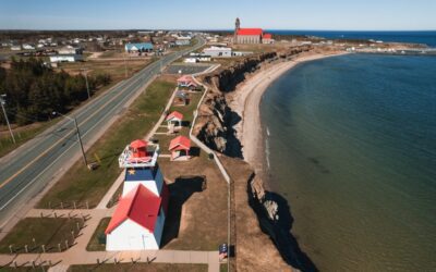
10. White River Suspension Bridge Hike, Coastal Hiking Trail | The Great Trail (recommended by Jennifer Dubois)
Location: Pukaskawa National Park, Ontario
Nearest Major City: The park is located near Marathon, Ontario – a 3.5-hour drive from Thunder Bay and a 5-hour drive from Sault Ste. Marie.
Season: Hattie Cove Campground is open May 15 to October 15; the Visitor Centre is open June to August. Weather conditions may influence the availability of facilities and services in early May.
Trail Rating: Moderate to difficult
Google Maps Link

This 18-kilometre (11.2 mile) hike takes you along the rugged and beautiful Coastal Hiking Trail in Pukaskawa National Park. For the well-prepared and adventurous hiker, this is an exhausting but unforgettable day hike traversing a rugged trail through thick boreal forest. You can stop for a rest halfway to the bridge at secluded Beach Playter Harbour (or turn around and head back if you want to make it a shorter hike).

A visitor enjoying the views of the White River Suspension bridge high above Chigamiwinigum Falls, Pukaskwa National Park

Read More on Hiking
From High Heels to Hiking Boots: How I Reinvented My Life to Travel Full Time
JourneyWoman CEO Carolyn Ray shares her ongoing journey of reinvention and advice on how women can travel full time.
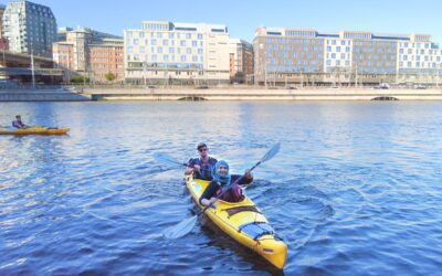
Why Kayaking is a Super Adventure Sport for Women in a Wheelchair
Our Accessible Travel writer Tanzila Khan discovers that kayaking is possible for adventurous women in a wheelchair, in Stockholm, Sweden.
New Brunswick’s Acadian Peninsula is a Cyclist’s Dream
Located in New Brunswick, the stunning Acadian Peninsula Veloroute is a network of 14 cycling circuits perfect for a three-day trek.
Amanda Burgess
Amanda Burgess is a Toronto-based writer and creative strategist whose bags are always packed for her next adventure. She is a Certified Cancer Journey Coach who creates a safe space for cancer patients and caregivers to design their dream lives – while living with cancer, and on the other side of it. Amanda freelanced for JourneyWoman until December 2021.
I love all your articles I really especially like this hiking when I’ve always been interested in doing a hiking trip I’m hoping that in 2022 you do have some hiking packages
Anna
Hi Anna, so happy to hear that you liked this article. It was a joy to put together. We’re not a tour/travel company, but we work with many! I can put out the feelers with our tour operators and see who might be offering hiking packages. Where in the world are you most interested in hiking? Shoot me an email at [email protected] and we can chat further.
I really enjoyed reading this article. So many beautiful places to explore in Canada.
One correction to the Slocan Valley trail. Yes, the whole area is glorious. BUT Slocan is 8 hours drive from Vancouver , not 4 hours. There are 5 mountain passes between Vancouver and Nelson or the Slocan.